Bingham Falls is a short walk from Route 108 in Stowe, and it earns its reputation every summer. The trail is just long enough to feel like you earned it, and the payoff is a narrow gorge with a waterfall dropping into a clear green pool big enough to swim in. If you’ve been told Vermont doesn’t have dramatic waterfalls, this is the counterpoint. Here’s what the hike involves, when to go, and what the experience actually looks like so you can plan accordingly.
How to Find the Trailhead
The trailhead for Bingham Falls sits along Route 108 (Mountain Road), roughly 6 miles north of Stowe village in the direction of Smugglers’ Notch. There’s a small pullout on the south side of the road. It won’t have a large sign or official parking infrastructure, so pay attention to your GPS once you’re on Route 108 heading away from Stowe village. The pullout fits around 8 to 10 cars, and on summer weekends it fills up by mid-morning. If you arrive and find no space, there’s limited roadside parking nearby, but keep completely off the travel lane and check local conditions before leaving your car.
From Stowe village, the drive to the pullout takes about 15 minutes on Route 108. If you’re coming from Burlington, head south on I-89 to Exit 10, then take VT-100 north to Stowe and follow Mountain Road out of town. Burlington to the trailhead is roughly 50 minutes without traffic.
Route 108 closes through the Notch in winter, typically from late November through late spring. The section from the height of the pass east toward Jeffersonville shuts to motor vehicles when snow accumulates. Bingham Falls is accessible year-round from the Stowe side of Route 108, but the trail is icy in winter and the pool is frozen. The practical visiting window is late May through mid-October.
The Trail Down
The path from the parking pullout drops steeply into the gorge. It’s short: plan about 10 to 15 minutes down. The footing is rough, with exposed tree roots, mud when wet, and loose rock near the bottom. Wear shoes with grip. Flip-flops work fine at the water’s edge if you want them for wading, but carry them down and change at the pool.
The descent moves through northern hardwood forest: yellow birch and sugar maple with a thick understory of ferns lower down. In summer the shade is immediate and the air noticeably cooler the moment you drop below the road. By early October the maples in the gorge turn gold and orange, which makes the hike down one of the better close-range fall foliage experiences in northern Vermont. The color here is intimate rather than panoramic. You’re walking into it rather than looking across a valley at it.
The total round trip from the pullout to the falls and back runs around 0.6 miles, with most of the effort on the return climb. Allow 45 minutes to an hour, not counting time at the water.
The Falls and the Gorge
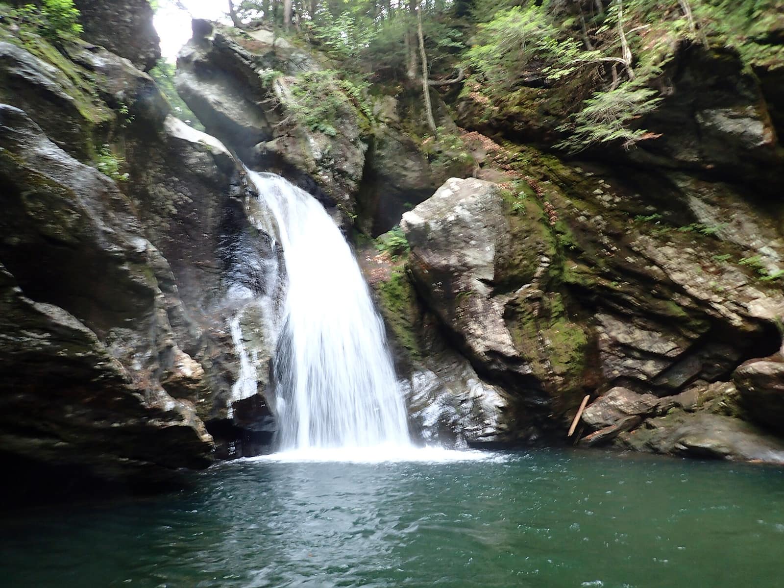
Bingham Falls drops off a ledge into a narrow rocky gorge where the walls rise on both sides and funnel the sound of the water into a small, enclosed space. The pool at the base is deep and clear, with the green color common to Vermont’s granite-fed swimming holes in summer.
The boulders around the pool are large and flat-topped, worn smooth by glacial action and years of moving water. On a warm weekday in July you can find a rock to yourself for lunch. On a Saturday in August, expect 30 to 50 people. The gorge keeps the area 10 to 15 degrees cooler than the road above, which is part of the appeal on hot days when the rest of Route 108 is warm and still.
The visual effect of the falls is best in spring when snowmelt pushes the flow up, but the pool is coldest and the current strongest then. High summer offers calmer water and easier swimming. Fall brings the foliage frame around the falls and fewer visitors, but the water is too cold for most people to stay in long.
Swimming at Bingham Falls
The pool is swimmable from late June through early September, though conditions shift across that window. In late May and early June, runoff from the upper Green Mountains keeps the water cold enough to take the breath away and the current is strong enough to require real effort to hold position near the base of the falls. By mid-July the flow mellows and the water temperature comes up enough for a reasonable swim: cold by pool standards, genuinely refreshing if you came prepared for it.
The depth at the base of the falls varies with seasonal flow. In summer the center of the pool is deep enough to swim in without touching bottom. There’s no lifeguard, no posted depth marker, and no safety infrastructure. Standard gorge safety applies: don’t jump from the rocks above or to the sides of the falls, check footing before you enter the water, and pay attention to how fast the current moves after recent rain. A significant thunderstorm upstream can push a fast pulse of cold water through a gorge like this with little warning. Check the weather forecast for the full northern Vermont region before you go, not just the forecast for Stowe village.
For broader planning on Vermont hiking and outdoor sites, the Vermont hiking overview covers Long Trail trailheads, day hike options across the state, and what to expect in terms of conditions and permits at the most popular spots. The Green Mountain Club also publishes current trail conditions reports for the Mount Mansfield and Stowe area.
When to Go
Late June through mid-September is the main window for Bingham Falls. The trail drains after spring, the pool is swimmable, and the gorge is at its greenest. Arrive on a weekday or before 9:30 a.m. on weekends if you want any chance of parking without a wait.
Late September through mid-October brings fall foliage. The gorge walls and the mixed hardwood forest above the trail turn first because of the elevation, and the color is close enough to see individual leaves rather than distant hillsides. The water is too cold to swim comfortably at that point, but the hike is worth it. This is one of the few Vermont waterfall walks where the autumn display is as much a reason to come as the falls themselves.
Winter and early spring are generally not worth the effort for most visitors. The trail ices over and the pool is frozen and dangerous near the base of the falls. Mud season (April through mid-May) makes the descent slippery and the pullout inaccessible in wet years.
The Vermont best-time-to-visit guide covers the full seasonal picture for the state, including when foliage peaks in the northern versus southern regions and how ski season timing works with shoulder-season access on mountain roads like Route 108.
What to Know Before You Go
Leave No Trace applies. There are no facilities at the trailhead: no toilets, no trash cans, no running water. Pack out everything you carry in. The gorge stays accessible to hikers because visitors follow basic principles about how to treat a sensitive, high-traffic natural area.
Dogs are strongly discouraged in the gorge area. The descent is hard on paws, the boulders around the pool are slippery, and a dog near the base of an active waterfall in a confined gorge creates real risk. Leave them at camp or with someone at the car if possible.
Cell service is thin on Route 108 between Stowe and the Notch. Save the pullout location and your trailhead coordinates while you still have signal in Stowe village.
Alcohol in gorge areas has drawn increased enforcement at Vermont swimming holes in recent years. Keep it reasonable.
If you have young children, hold hands on the descent. The boulders around the pool look stable and some are not. Keep kids back from the rocks adjacent to the falls base.
Pairing Bingham Falls with Smugglers’ Notch
Bingham Falls sits on the Route 108 corridor, which puts it a few miles from Smugglers’ Notch in either direction. The Notch itself is about 4 miles further up Route 108 from the falls pullout. The road narrows dramatically through a boulder-strewn pass between the cliffs of Mount Mansfield and the flanks of Madonna Mountain. The drive from the falls to the height of the pass takes about 10 minutes. Pullouts at the top give room for photographs. You can continue through toward Jeffersonville to see the full pass, or turn around and head back to Stowe.
Back in Stowe village, around 15 minutes south on Route 108, you have the full range of restaurants, shops, and access to the Stowe Recreation Path along the West Branch River. The 5.3-mile paved path is flat, well-maintained, and good for a leg-stretching walk after a morning at the falls.
Getting There and Logistics
The Bingham Falls pullout is on the south side of Route 108, roughly 6 miles north of Stowe village. There’s no numbered street address. Searching “Bingham Falls Stowe Vermont” in Google Maps or Apple Maps takes you to the correct location.
Burlington International Airport (BTV) is the nearest major airport, about 50 minutes from the trailhead by car. Car rental agencies are at the terminal. There is no bus or shuttle service from Burlington to Stowe or along Route 108, so a rental car is required. Stowe village has gas stations and a grocery store on Mountain Road if you need to stock up before heading out toward the Notch.
Photo credit: Outdoor Craziness, CC BY-SA 3.0