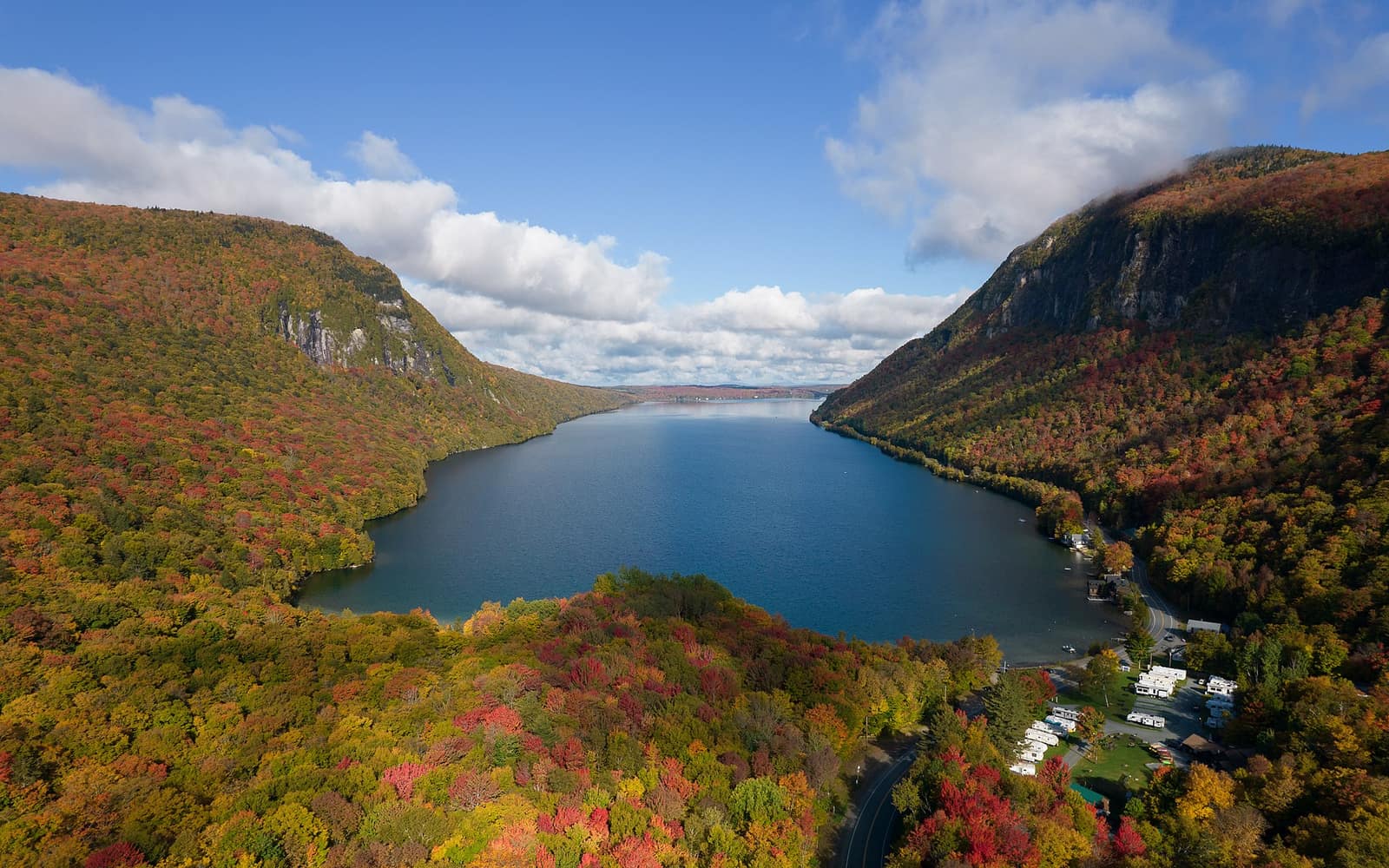
Lake Willoughby Vermont doesn’t look like the other lakes on the map. Most Vermont lakes sit in open valleys or against rolling hills. Willoughby is pinched between two cliffs, a five-mile-long body of glacial water with Mount Hor pressing in from the west and Mount Pisgah rising sharply from the east. From the right angle, and you’ll see it from Route 5A as you come around a bend in Westmore, the effect is something like a fjord dropped into the Northeast Kingdom. That first look tends to make people slow down.
The lake is in Orleans County, about 25 miles north of St. Johnsbury and roughly an hour and 45 minutes northeast of Burlington. It’s accessible, but not on the way to anywhere. You go to Lake Willoughby Vermont because you’re going to Lake Willoughby.
What Makes Lake Willoughby Vermont Different
The lake was carved by glaciers, which explains both its shape and its depth. At roughly 300 feet, Willoughby is one of the deepest lakes in Vermont, and the cold water stays clear through the summer. The cliffs of Mount Pisgah on the eastern shore rise more than 1,000 feet above the water. Mount Hor on the west is slightly lower but similarly abrupt. Together they create a narrow southern arm where the lake deepens and the rock faces drop nearly straight into the water.
This is Northeast Kingdom terrain: rural, forested, and relatively uncommercial compared to the ski towns to the west and south. There are camps and vacation rentals scattered along the lakeshore, a lakeside inn, and a state forest covering both mountainsides. That’s about it. The lack of development is part of what makes the lake worth the drive.
Swimming and the Town Beach
The main swimming area sits at the northern end of the lake, where Route 5A passes closest to the water in Westmore village. The beach is sandy and accessible, and the surface water warms enough for comfortable swimming by mid-July. It drops off fast as you move south into deeper water, which is worth noting if you’re swimming with children. Parking fills on hot summer weekends, so arriving before 10 a.m. or after 3 p.m. saves you from circling.
The southern end of the lake has no public beach access. It’s wilder, with the cliff faces closing in and private camps on the shoreline. You see it best from a boat or kayak. The cliffs at the south rise nearly vertically from the water, and peregrine falcons nest on the upper ledges of Mount Pisgah each spring. Vermont State Parks restricts portions of the Pisgah south cliff trail seasonally to protect nesting birds, typically from April through mid-summer. Check current trail status on the Vermont State Parks website before planning a hike near those cliffs early in the season.
For a broader look at swimming options across the state, the best swimming holes in Vermont page covers Willoughby alongside other glacial and river spots worth the detour.
Hiking Mount Pisgah and Mount Hor
Both mountains flanking the lake are state forest land with maintained trails. Neither requires technical gear, but both are steep enough in sections to demand attention, especially after rain when rock steps get slick.
Mount Pisgah
The Pisgah North Trail starts from a small parking area on Route 5A on the lake’s east side. The trail climbs about 1.5 miles to the summit at 2,736 feet, gaining roughly 1,500 feet of elevation. The upper section follows the cliff edge, with open views down to the lake and west across to Mount Hor. On a clear day you can see well into Quebec from the top. A South Trail continues from the summit down to the lake’s south end, but completing a full loop requires either a second vehicle or a road walk along Route 5A back to your car.
The cliff-edge section is exposed. There’s no railing at the overlooks, and the drop is real. Use good judgment about how close to the edge you take younger hikers.
Mount Hor
Mount Hor is reached from a trailhead parking area on Hinton Hill Road, off Route 5A on the western side of the lake. The trail runs about 1.2 miles one way to the summit (2,648 feet), with steep pitches near the top. The east-facing overlook gives you the best full view of the lake and the Pisgah cliff face across the water. It sees fewer hikers than the Pisgah trails, and the perspective is slightly different: you’re looking directly at the cliff wall rather than down from it.
Both mountains connect to Vermont’s broader hiking network, though neither is on the Long Trail, which follows the main Green Mountain ridge further west.
Fishing Lake Willoughby
Willoughby is a serious trout lake. The cold, deep, clear water and the lake’s relative isolation keep it productive for lake trout, rainbow trout, and brown trout, along with walleye and yellow perch. Most serious fishing happens from a boat, either trolling deep for lake trout or working the shallower north end for browns and rainbows in spring and fall. Ice fishing draws anglers in January and February when the ice sets solidly, which happens most winters but not every one.
Vermont freshwater fishing licenses are required for anyone 15 and older. Non-resident licenses are available online through the Vermont Fish and Wildlife Department before your trip. Regulations for Willoughby include seasonal restrictions and catch limits that change year to year, so download the current digest rather than relying on last year’s rules.
There are no boat rentals at the lake. A hand-launch area near the north beach accommodates kayaks and canoes. Motorized boats are allowed; there’s no marina or fuel on the water, so bring what you need.
When to Visit Lake Willoughby Vermont
Summer (July and August) is the swimming and paddling season. Surface water reaches the upper 60s Fahrenheit by mid-July. Foliage crowds haven’t arrived, and the trails on both mountains are passable. Weekends at the beach get busy; weekday visits are noticeably quieter.
Fall (late September through mid-October) is when the views from the summit overlooks earn their reputation. The Northeast Kingdom peaks earlier than the rest of Vermont, typically around September 20 through 28 in a normal year. From the overlooks on Pisgah and Hor, the lake sits below a hillside of sugar maples in red and orange, with the water reflecting whatever sky is overhead. For detailed timing by region, the Vermont fall foliage guide covers when to go and which parts of the state turn first.
Winter closes the beach and makes the mountain trails icy without microspikes. The back roads around Westmore can be difficult without four-wheel drive when they freeze or drift over. Ice fishing begins once the lake freezes to safe thickness, which most years happens in late January.
Spring (May and June) starts with mud season. The dirt roads in Orleans County are often soft or impassable in April. Fishing picks up in late May. Trails dry out by June in most years, and the lake is cold but swimmable by late June for those who don’t mind it.
For a season-by-season look at the full state, the best time to visit Vermont page breaks down what each window offers across all regions.
Where to Stay Near Lake Willoughby
Willoughvale Inn sits directly on the lake in Westmore and is the closest option if you want to be on the water. The property has inn rooms and lakeside cottages. Rates rise during foliage season, so book well ahead for late September and early October visits.
St. Johnsbury, about 25 miles south via I-91 and Route 5, is the nearest town with a broader range of lodging, including chain motels and a few smaller inns. The drive from St. Johnsbury to the lake takes about 35 minutes on two-lane roads. If you’re combining Willoughby with other Northeast Kingdom destinations like Burke Mountain or the Lamoille Valley Rail Trail out of Lyndonville, St. Johnsbury makes a reasonable base.
Camping is available at Brighton State Park near Island Pond, roughly 25 miles to the northeast, and at Maidstone State Park about 40 miles east in Guildhall. Neither is on the lake, but both are within the Northeast Kingdom and close enough for a day trip to Willoughby.
Getting to Lake Willoughby
From Burlington, take I-89 North to I-91 North, then exit toward Barton and follow Route 5A north to Westmore. Total drive time is about 1 hour and 45 minutes in normal traffic. From Stowe, head east on Route 2 through Montpelier and St. Johnsbury, then north briefly on I-91 before picking up Route 5A north, a drive of roughly 1.5 hours.
Route 5A runs the full length of the lake’s eastern shore and is the primary road in. It’s paved and well-maintained. The side roads in Westmore, including Hinton Hill Road where the Hor trailhead sits, are unpaved and can be rough after wet weather. A standard two-wheel-drive car handles them fine in summer; avoid them when muddy or icy.
There is no public transit to Westmore. A car is required.
For more on driving in the Northeast Kingdom, getting around Vermont covers the logistics of a state that runs on two-lane highways and back roads.